
In transcribing the following paragraphs from the Internet Archive online version of The Imperial Gazetteer’s entry on Hindustan, I have expanded the abbreviations for easier reading and added paragraphing and links. This mid-Victorian reference work has substantial sections on both India and Hindustan, and it is not always clear how Victorians distinguished between the two. The title-page bears the date 1856, but internal evidence in various entrees makes clear that the text dates from 1851 or 1852. This discussion of British India has particular importance because it immediately precedes the 1857 Mutiny.— George P. Landow]
HINDOOSTAN [Persian, Hindust'han, the country of the Hindoos, or Negroland] is an extensive region consisting of the central of the three great peninsulas of Southern Asia, and extending between latitude 8˚ and 35˚ north, and longitude 68˚ and 91˚ east; bounded, north by the Himalaya Mountains, west by the Indus and the Indian Ocean, east by the Brahmapootra, the Bay of Bengal, the Indian Ocean, and Palk’s Strait, with the Gulf of Manaar, which separate its south part from the island of Ceylon.
Its extreme length, north to south, from the Himalaya to Cape Comorin, is about 1900 miles; and breadth, west to east, 1500 miles Its area may be estimated at nearly 1,280,000 square miles, or more than one-third of the entire extent of Europe; and its population has been supposed to amount to upwards of 147,500,000, or considerably more than half of the number occupying the European continent and islands.
Geographically, this region is separated into two grand divisions Hindoostan proper, between the Himalaya and the Vindhyan Mountains, in about latitude 23˚ north (this division also including the Punjab and Scinde); and what is more strictly called Peninsular India, bounded, west and east, by the Indian Ocean; and which is again subdivided into the Deccan (Dakshina, the south ), and India-south-of-the-Krishna, or Kistnah river, extending from that river, in about latitude 16 north, to Cape Comorin, and em bracing the greater part of the British presidency of Madras.
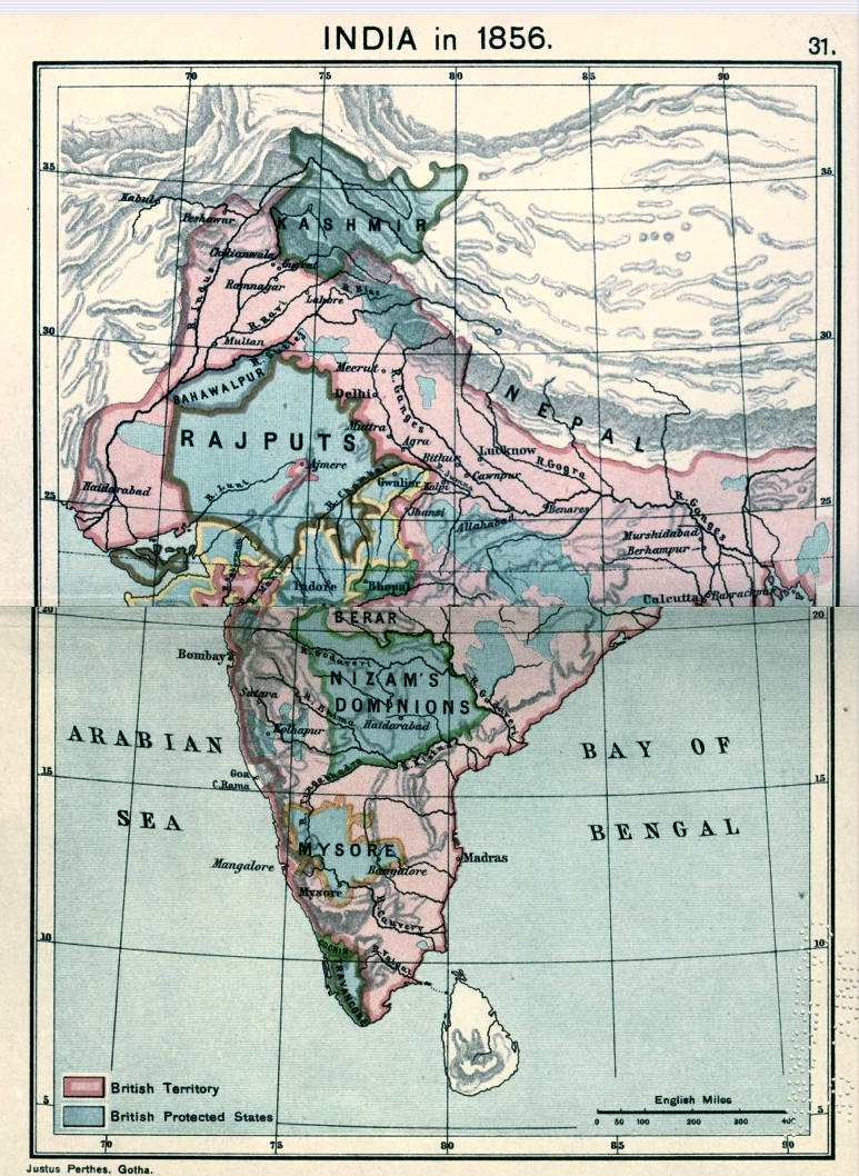
India in 1856. From Joppen’s Historical Atlas of India (1914). Click on image to enlarge it.
By the natives the country is further subdivided, according to the various languages or dialects spoken in its several parts. Thus, the Tamul [Tamil] nation inhabit the south part of the peninsula; north of these are the Karnata race; the Mahrattas, stretching through the west half of India; the Ooriya and Telinga races, in the central east part; the Ben galis to the north east of these; the Hindi, or Hindoostanees, occupying all the upper plain of the Ganges and Jumna which last have given name to both India and Hindoostan proper, and are, in general, physically and intellectually supe rior to the other Indian races. But Europeans are less fami liar with the foregoing subdivisions than with those instituted by the Mahometan conquerors of India; which, with a few provinces still retaining their native designations, may be thus tabulated:
Great Divisions. Mahometan. &c., Provinces.1. Hindoostan Proper, north India
Agra
Delhi
Malwa
Rajpootana (or Ajmere)
Goojerat
Cutch
Scinde
Mooltan
Lahore
Cashmere
Kumsom
Gurhwal
Nepaul
Oude
Allahabad
Baliar
and
Bengal

India in 1805.
2. The Decccan, &c
Candeish
Berar
Aurungabad
Beeder
Hyderabad
Gundwana
Orissa
the Northern Circars,
and a part of Bejapoor.
3. India South of the Kistnah
Part of Bejapeor
Cram
Belaghaut
Cram
Mysore
Salem
Coimbatoor
Malabar
Travancore,
Madura
and the Carnatic.
Since the European conquest of India, however, these sub divisions also have, for the most part, become obsolete; and the whole of Hindoostan, Nupaul excepted, is now included in the British presidencies of Bengal, Madras, Bombay (and La hore), and the native states dependent on the same, which will be found enumerated in our article INDIA (BRITISH).
Related material
Bibliography
Blackie, Walker Graham. The Imperial Gazetteer: A General Dictionary of Geography, Physical, Political, Statistical and Descriptive. 4 vols. London: Blackie & Son, 1856. Internet Archive online version of a copy in the University of California Library. Web. 7 November 2018.
Joppen, Charles. Historical Atlas of India. London: Longsmans, Green, 1914. Internet Archive version of a copy in the University of California Library. Web. 1 October 2014.
Last modified 10 December 2018