
[Except for the book-cover, the accompanying illustrations are from photographs and scanned images by the author of this review and other contributors to the Victorian Web. Click on the thumbnails added by George P. Landow for larger images and additional information.]

Cover of the book under review.
Published to coincide with the Port of London Authority's Centenary in March 2009, this collaborative work provides a brilliant record of the changes in the old working Thames, in other words, its waterfront from London Bridge and the Pool of London to Greenwich and the Isle of Dogs. The basic point of reference is the ten-mile panorama commissioned by the PLA in 1937, taking in roughly five miles on each bank. This is shown in segments with the current view below it. But unlike two previous books in 1988 and 2000, the former focusing on the original panorama, and the later juxtaposing the old and new panoramas, this one includes illustrations relating to the earliest days of the docks. As a result, it supplies a fuller and richer historical record of the industrial architecture along here, as well as updating the more recent book by showing the latest riverside developments.

The Fighting Temeraire tugged to her last Berth to be Broken up. Joseph Mallord William Turner
In Victorian times, the Thames along this stretch fizzed with activity, with docks, wharves, warehouses, boatyards and works of all kinds lining its banks, and tall-masted sailing ships crowding its waters. Cargoes of tobacco, wine and many other commodities poured in; goods from grain to flower bulbs were stored in bulk; oil-seeds were crushed, flour milled and biscuits baked; paint was manufactured, chains, anchors and iron and steel girders were fabricated; and, of course, sailing vessels of all kinds, including barges, were built, repaired or (like the famous warship Temeraire in 1838-9) broken up here. As that indefatigable writing team, Samuel Carter and Anna Maria Hall, put it in 1859, "To a stranger there is no more curious and instructive sight than the London Docks, and nothing can give a better idea of the vast wealth and trade of the British Islands" (473). The arrival of large steam and container vessels, which could not be accommodated this far downriver, brought progressive decline, and what still seemed picturesque to a late-Victorian illustrator like Joseph Pennell then revealed only its darker, Dickensian, squalid side. In this way, the stories of the individual wharves gives a unique insight into Victorian and early twentieth-century economic and social conditions. Now, the ongoing regeneration of the docks area is changing the scene again both radically and rapidly, and a record like this is the only way to keep the most interesting elements of the past alive in the present.
Chapter 1 gives the history of Thames panoramas, right from mid-sixteenth-century Dutch and Flemish artists' "long-view" panoramas, through Whistler's unflinchingly honest "Thames Set" etchings of 1859-61, to the age of photography. In fact, the earliest photographs predate Whistler's etchings: a photograph of Brunel's SS Great Eastern, reproduced in Chapter 5, was taken on 2 November 1857, just days before the initial attempt to launch her, with three horses among the workers, and two figures in top hats (might one have been Brunel himself?) on the other side of the hull. Photographic records, however, were scant until the PLA commission — perhaps, suggest the authors here, because of the difficulty of getting down to the waterfront with the kind of equipment needed in those days. Thus another early photograph in Chapter 5, dating from 1885, turns from the riverfront itself to show the yard of a coconut fibre works off West Ferry Road, where rope and matting were produced. Beside great mounds of coconut shells stand workmen and supervisors, with another top-hatted man (probably the owner) as well as two women and a small boy looking on.


Left: Hay's Galleria. Right: Pickle-Herring Wharf. [Click on thumbnails for larger images.]
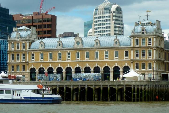
However, all this kind of riverine activity has long since ceased, and the changes to each stretch of the river are displayed and discussed in Chapters 2-9, starting in Chapter 2 with the Upper Pool, North Bank (that is, the City side), swinging to the South Bank at Greenwich in Chapter 6, and returning again in Chapter 9 to the Upper Pool, but this time on the South Bank (that is, the Southwark side). A handy little diagram of the river, with an arrow identifying the stretch under consideration, sits at the top of most double pages. The Upper Pool, of course, was the very heart of the old Port of London. Several important buildings remain on the North Bank: the Custom House, with its river frontage built by Sir Robert Smirke (1825-27; still used by HM Revenue and Customs today); the second Victorian Billingsgate Market, its 1870s building by Sir Horace Jones now a smart corporate events venue; and the old seventeenth-century Vinters' Hall, still looking grand and prosperous. On the opposite bank, too, Chamberlain's Wharf, built in the 1860s, is still there, though now converted behind its façade into the private London Bridge Hospital. All the way along both banks, to Greenwich and back again, those warehouses that remain have been or are being adapted to modern needs, principally for housing. Oliver's Wharf, Wapping, which was "built in 1870 in Tudor Gothic style for George Oliver," and originally "handled general cargo but had special facilities for tea" (Craig et al. 45), was one of the first to be converted to flats. Others, like Metropolitan Wharf, also in Wapping, have been converted for mixed use, incorporating both flats and office space; and some now house shops, restaurants, bars and hotels. At the particularly historic south bank of the Pool, close to London Bridge, the enclosed dock added by Sir William Cubitt in 1856 has been filled in and covered to create a mall, Hay's Galleria; while the Hilton Docklands hotel makes use of old warehousing at Columbia Wharf, Rotherhithe, which once sported "the first grain silo in a British Port" (Craig et al.162).


The Docklands and riverside today: West India Docks, Wapping Pier, and Horace Jones's Billingsgate Market. [Click on thumbnails for larger images.]
Despite the preservation of certain old buildings, the changes have been enormous. Except in the panoramas showing protected landmarks like the Tower of London, the Old Royal Naval College and a few other stretches, the waterfront is almost unrecognisable. After all, even the former warehouses look different, having been "transformed dramatically by sandblasting, cleaning and re-pointing the brickwork, and replacing the loophole doors with windows and balconies" (Craig et al. 43). Demolition and rebuilding, of course, has wrought even more striking changes. The most striking of all comes in Chapter 9, where Sir Norman Foster's bulbous glass-paned "fencing mask" City Hall, and other more conventionally designed office blocks, stand gleaming impudently across at the ancient Tower. This is where the picturesquely-named Pickle-Herring Wharf and its stairs were lost, among others. Still, some poignant reminders of the working river remain: the Wapping Old Stairs by Wapping Pier, for example, and the towering quay-side cranes at West India Dock, though these are within the enclosed dock area rather than on the river itself. Alongside these is the permanent mooring of SS Robin, thought to be the world's last complete, working steam coaster, now in the process of being restored in dry dock at Lowestoft. For those who want to explore, there is still plenty to find in the hidden corners of Docklands, as well as in the Museum in Docklands, splendidly housed at a converted warehouse in the same historic West India Dock.
However, back to the riverfront itself. Perhaps the single best vantage point for taking a general view of the Docklands is from over the old Royal Naval College at Greenwich Hill, and the authors have reproduced an amazing photograph taken from here as early as 1856. But producing a whole unbroken panorama of the river banks, in such a way as to make meaningful comparisons with an earlier one, presented many challenges. Even professional photographers are prey to the elements: "It was impossible to shoot South Bank pictures on a bright sunny day, particularly with the low spring sun" (Craig et al. 223); there was fog, too, while changing water levels presented problems of continuity. Other issues on the technical front concerned image distortion and perspective. Access could still prove awkward, in areas of private or commercial usage, bomb-sites (yes, still!) and building sites (a feature of this part of London now and forever, it seems). The Thames waterfront is a work in process; and this fascinating book will doubtless serve as a reference point for future generations, as this part of the river continues to be shaped by the city's needs.
References
Craig, Charles, Graham Diprose and Mike Seaborne, with Chris Ellmers and Alex Werner.London's Changing Riverscape: Panoramas from London Bridge to Greenwich, London: Frances Lincoln, 2009. 240pp. �30 / $50. ISBN 978-0-7112-2941-9.
Hall, Samuel Carter and Anna Maria. The Book of the Thames from Its Rise to Its Fall. 1859. Republished 5th ed. Teddington, Middlesex: Charlotte James, 1980.
Last modified 31 August 2016