
In transcribing the following paragraphs from the Internet Archive online version, I have expanded the abbreviations for easier reading. — George P. Landow]
York or Yorkshire, tbe largest county of England, is bounded pn the north by the Tees, separating it from county Durham; on the East by the North Sea; on the southeast by county Lincoln, from which it is mostly separated by the Humber; on the south by counties Nottingham and Derby; on the southwest by a small projection of Cheshire; and on the west by Lancashire and county Westmoreland; Its greatest length, east to west, measured on the parallel of 54° north, 90 miles; central breadth, 80 miles; area, 5983 square miles.
The coast, from the mouth of the Tees to the magnificent chalk-cliffs of Flamborough Head, which rise 300 feet above the sea, is bold and rocky, but immediately beyond begins to descend, and from Bridlington Bay to Spurn Head, lies low, and exposed to the constant ravages of the sea. The interior, viewed generally, consists of a long and wide central valley, stretching south-southeast from the north frontiers of the county to the Humber, and inclosed both east and west by tracts of considerable elevationorth On the east side these tracts form in the north bleak moorlands, rising often to a height of above 1000 feet and sometimes above 1400 feet, and extending from 20 miles to 30 miles inland from the coast, on which their terminations are seen in the bold cliffs already referred to. In the south part of the east side, the heights, here called Wolds, become lower, and instead of reaching to the const, recede so far from it as to leave a large alluvial tract known by the name of Holderness. On the west side of the central valley, the heights gradually increase, and ultimately become part of what is called the English Pennine chain, the loftiest points of which, within the county, are Whernside, Pennigant, Ingleborongh, and Bowfell, with the respective heights of 2384 feet, 2270 feet, 2361 feet and 2911 feet.
The central valley is both narrow and elevated in the north, but gradually widens out as it descends, and finally, as it approaches the Humber, becomes a large and somewhat swampy flat. The Humber receives almost all the drainage of the county by the Ouse, and its tributaries are the Swale, Yore, Wharfe, Derwent, Aire, and Donorth A small part of the west is drained by the Kibble, of the north by the Tees, and of the east, directly by the German Oceanorth
There are no lakes deserving of the name. The southeast part of the county is covered with alluvial deposits. Immediately north and west the cretaceous formation stretches in a curve, first from Flamborough Head westward, and then south through the Wolds to the Humber. The far greater part of the north moorlands is oolitic, but a belt of lias, commencing a little south of Whitby, skirts the coast north to Huntcliff, and then takes a very circuitous direction, first southwest through Hillsborough to Northallerton, then south past Thirsk to the valley of the Swale, and finally, in a line so wavering as almost to baffle description, through Easingwold, Pocklington, and Market-Weighton, where it comes into contact with the chalk. Outside and immediately north and west of the irregular belt of lias now described, the new red sandstone becomes largely developed, extending along the banks of the Tees, then south into the valley of the Swale, and then widening out so as to cover a large part of the vale of south Ouse. The new red sandstone is succeeded by the magnesian limestone, which stretches continuously through the county from north to south, seldom, however, attaining a width of above 5 miles. This limestone, in the south of the county, forms the east edge of the great centre coal-field of England, of which Yorkshire thus possesses a valuable portion, extending north from Sheffield to Leeds, and west from Pontefract to Huddersfield. The coal-field is underlain north and west by the millstone-grit, which is succeeded throughout the west by the mountain limestone, of which all its loftiest summits are composed.
The properties of the soil differ much according to locality. In the north, where moorlands prevail, good arable land is almost entirely confined to a few well-sheltered valleys, and the far greater part of the available surface is devoted to grass-husbandry, for the rearing of stock, particularly horses. The Wolds consist generally of a light friable calcareous loam, well adapted for barley and turnips, though perhaps more profitably employed in permanent pasture, as it is apt to deteriorate under the plough, and cannot be maintained in fertility without heavy doses of manure. The central valley, particularly where it widens out, contains rich tracts, admirably fitted for any agricultural purpose. The alluvial tracts of Holderness and the banks of the Humber, where thousands of acres have been gained by warping, are celebrated for their luxuriant crops of wheat, beans, and hay.
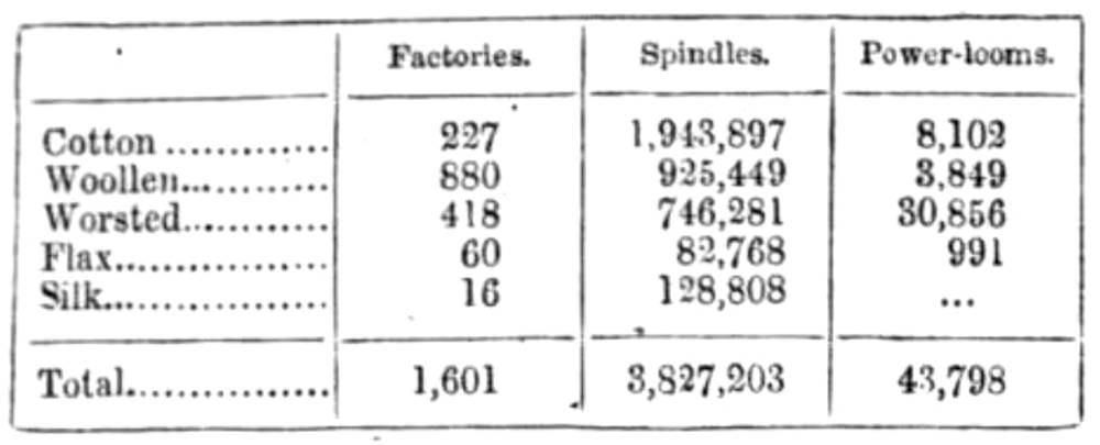
Manufactures have made great progress, particularly in the west and south, where some of the leading branches of national industry have long fixed their seat. Among others may be mentioned the woolens of Leeds, Bradford, Halifax, Huddersfield, and Wakefield; the linens of Barnsley, the cast and malleable iron of Low Moor and other extensive iron-works, and the hardware, cutlery, and plated goods of Sheffield. the following table shows the number of factories at work in 1850, with the number of spindles and power looms they contained: —
Yorkshire is divided into three Ridings— north, east, and west, which have their common point of junction near the city of York; and sends 117 members to Parliament. Its means of communication, though somewhat deficient in the north, owing to the difficult nature of the ground, are abundant in the south, where almost every important stream has been made the feeder of a canal, and many engineering works of great magnitude and difficulty have been executed. The leading lines of railway are the London and North Western, the Midland, the Lancashire and Yorkshire, the Manchester and Sheffield, the Great Northern, the Stockton and Darlington, the York and North Midland, and the York, Newcastle, and Berwick railways. In consequence of the formation of these lines and accompanying branches, the traffic of the County has greatly increased. Population 1,797,995. [IV, 1269-70]
Bibliography
Blackie, Walker Graham. The Imperial Gazetteer: A General Dictionary of Geography, Physical, Political, Statistical and Descriptive. 4 vols. London: Blackie & Son, 1856. Internet Archive online version of a copy in the University of California Library. Web. 7 November 2018.
Last modified 26 April 2019