

uropean settlement occurred in Katikati on the Western Bay of Plenty, in 1875 when a group of Ulster Irish families arrived on the eastern coast of New Zealand's North Island aboard the Carisbrook Castle to cultivate and build lives here. They were shortly followed in 1878 by another group of settlers aboard the Lady Jocelyn. Their leader was George Vesey Stewart (c.1832-1920), a man possessed of great vision and determination, who is credited with having encouraged about 4,000 people in all to emigrate to New Zealand (Rorke). Among the passengers of the Lady Jocelyn were Stewart's parents, his brother Hugh, and Hugh's wife, Adela. It is thought that Katikati is the only dedicated Ulster Irish settlement in the world.
When the families arrived, the land was virgin bush, entirely undisturbed. Being of tough stock, the settlers set to work, clearing the land, building homes of local timber and planting crops of oats, potatoes and maize. The buildings did not last well as they were built from native timber which was unfamiliar to the recent arrivals. Many were also destroyed by fire. By the 1950s and 60s, most of the large homesteads built by the founding fathers of the town were gone; abandoned, burned to the ground or demolished. Fortunately, one of George Vesey’s daughters, Emily Surtees (1857-1957), became a competent photographer, apparently developing the negatives herself, "using dangerous chemicals and methods to achieve success" ("Surtees, Emily"). Her photographic record of the people and environment in the Katikati district taken between 1989-1900 is very highly valued.
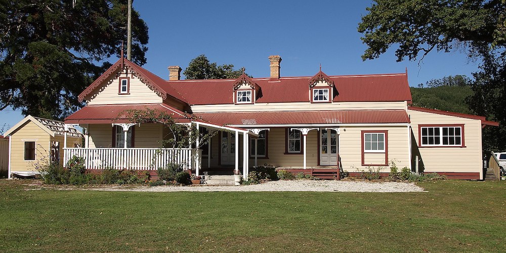
Athenree Homestead, restored. Photo credit: Ulrich Lange, Dunedin, New Zealand, originally posted on Wikipedia on the Creative Commons Attribution-Share Alike 3.0 Unported license.
One of the homes she photographed was Athenree Homestead which was built by Vesey Stewart’s brother Captain Hugh Stewart with his wife Adela. Athenree Homestead was built shortly after their arrival in 1878 and was a social hub of the district for the settlers. Adela planted the garden in flowers and loved having parties and dinner dances which went on far into the wee hours of the morning, when partygoers would make their way home in the light of the full moon. The Māori leader and founder of the Ringatū religion Te Kooti Arikirangi Te Turuki also paid a visit as a part of his tour of the country. Adela served him tea in her drawing room. Captain Stewart and Adela left New Zealand in 1906 and returned to England, but the house continued to be lived in until the 1950s when it fell into ruin, ending up as a hay barn. That was until an intrepid local band of history fans were determined to restore it. Against all odds, this was done, and Athenree Homestead is now used as a wedding and conference venue and is open every month to visitors.
Soon after Hugh and Adela had built their home, the first church was erected. St Peter’s Anglican Church was built in 1883 by local builder William John Gray out of kauri wood, a most beautiful hard native timber. It still stands and is a heritage listed building with Heritage NZ|Pouhere Taonga.
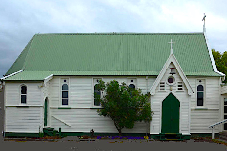
St Peter's Anglican Church, 2015. Photo credit: Bruce Ringer, from the Bruce Ringer Collection in Auckland Libraries Heritage Collections 3003-1809, kindly made available on the Creative Commons Licence (Attribution CC BY).
It must be acknowledged that the land cultivated by these new settlers was acquired in a less than desirable manner from the indigenous population of Māori tribes. The district in which Katikati is located was known as the “Te Puna Purchase.” Local historian Chris Bedford has written an account of how the land here was acquired by representatives of the colonial government, in what was admittedly "Confiscation in Disguise," concluding that "such inequities as occurred," as the immigrants sought to establish themselves in a new land, do need to be re-dressed now (19).
There are three marae in the area. The one closest to the township itself is Te Rereatukahia Marae. Just north of the township is Tuapiro Marae, then further north towards Waihī Beach is Otawhiwhi Marae (these can all be located on the Maori Maps; see bibliography). Māori had no concept of individual title to land. It was communally used and cultivated as necessary for their own people and many tribes, or iwi as they are known, found themselves at a real disadvantage through no fault of their own as many unscrupulous opportunists swooped in and made themselves very wealthy at the expense of the Māori people.
Use of the land changed from crops to cows, as the need for milk products increased. The first dairy factory was built and opened in 1902 and cows continued to be farmed all over the district until the 1970s when kiwifruit arrived, and acres of paddocks filled with cattle changed to shelterbelts behind which kiwifruit vines grew. Avocados began to be grown at around the same time, and Katikati is now known as the avocado capital of New Zealand. Many of the orchards grow a combination of kiwifruit and avocados which are both exported all over the world.
Bibliography
Athentree Homestead. Web. 16 September 2025.
Bedford, Chris. "Confiscation in Disguise - the Katikati-Te Puna Purchase."
Heritage New Zealand|Pouhere Taonga. Web. 16 September 2025.
Maori Maps: Te Rereatukahia Marae; Tuapiro Marae; and Otawhiwhi Marae. Web. 16 September 2025.
Rorke, Jinty. Stewart, George Vesey. Dictionary of New Zealand Biography – Te Ara. Web. 16 September 2025.
St Peter's Anglican Church. Western Bay of Plenty District Libraries. Web. 16 September 2025.
Surtees, Emily Charlotte Sophia. Western Bay of Plenty Community Archives. Web. 16 September 2025.
Created 16 Seotember 2025