
In transcribing the following paragraphs from the Internet Archive online version of The Imperial Gazetteer’s entry on Madras, I have expanded the abbreviations for easier reading and added paragraphing, subtitles, and links. The table is from the original. The title-page bears the date 1856, but internal evidence in various entrees makes clear that the text dates from 1851. This discussion of a major city in British India has particular importance because it immediately precedes the 1857 Mutiny.— George P. Landow]
The Presidency of Madras is one of the great territorial divisions of British India, bounded in the North by the presidencies of Bengal and Bombay, the Nizam’s dominions, and Nagpoor, and on the East, West, and South by the Indian Ocean. It comprises the larger portion of peninsular Hindoostan, embracing the whole of the Carnatic, and, extending across the peninsula, includes all the British territory — Malabar, Canara, &c. — South and West of Mysore, whoch later, as well as Travancore, it completely encloses. Its latitude is 8 to 20 North; longitude 73 to 85 E.
For revenue purposes it is divided into twenty-one divisions or collectorates, of which eighteen are regulation districts under the Madras government, and three are non-regulation districts under the control of an agent of the governor; their names, area, and population are as follows:
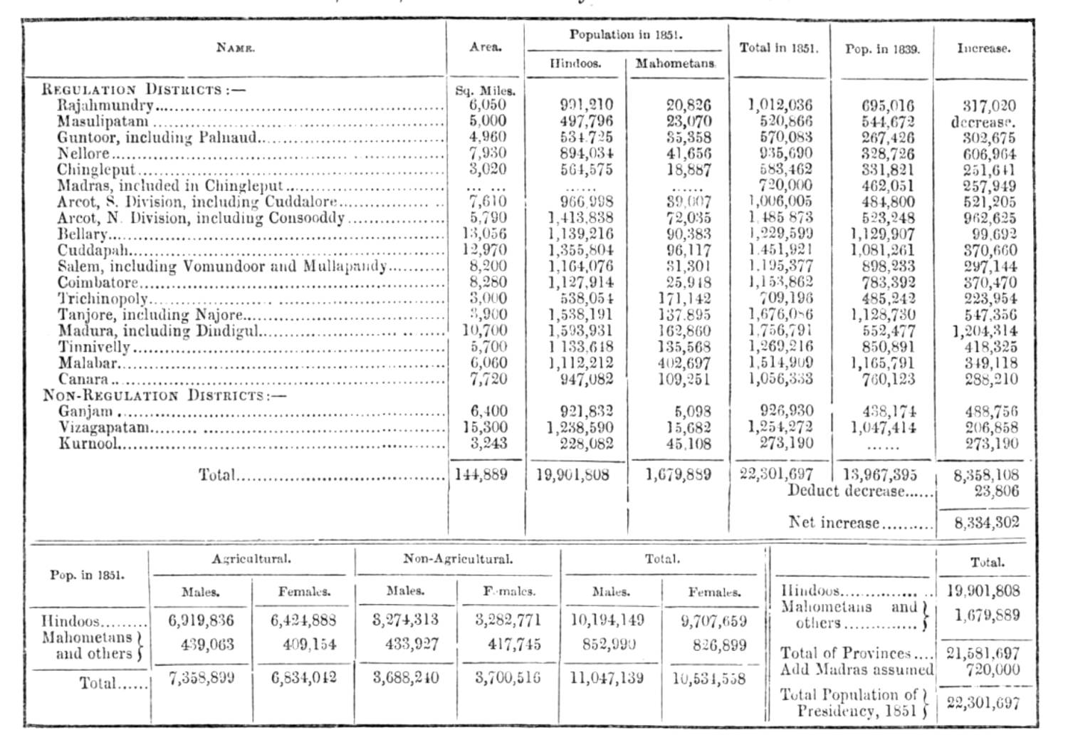
Division, Area, and Population of Madras Presidency. Click on image to enlarge it.
The Geography and Climate of Madras
The central portion of the presidency is occupied by a tableland, surrounded on all sides by an undulating or plain country, gradually decreasing in height as it approaches the sea, the whole enclosed East, West, and South by three mountain ranges, called, respectively, the East and West Ghauts, and the Neilgherry mountains. The two former run parallel to the East and West coasts, the third traverses the peninsula from Southwest to Northeast, forming a connecting link between them. (See GHAUTS). The Neilgherry range forms a mountain tract of about 42 miles in length, and 14 East and West broad, with a general elevation of 5000 ft.
The principal rivers are the Godavery and Kistna or Krishna, with their tributaries; and the Pennaar, Palaur, Punnair, Cavery, Coleroon, and Vighey. There are no lakes of any importance, but many salt lagoons or inlets of the sea.
The climate generally is reckoned the hottest in India, but differs widely in different localities according to elevation; passing from the low places on the coast, which are the hottest, through all the gradations of temperate regions, till, on the tops of the Neilgherries, the thermometer in the cold season falls to 31. The heat on the Est side of the peninsula, where, at the mouth of the Kistna, it has been known as high as 108 at midnight, is much more excessive than on the West side; but, even in the hottest places, the air is cooled and the ground refreshed in May, June, and July by frequent showers, or by torrents of rain.
The soil along the coasts, particularly those of the Carnatic, is for the most part light and sandy; inland it consists of a decomposed syenite, impregnated with salt, which, in dry weather, covers the ground with a saline efflorescence; still the district of Tanjore, on the banks of the Coleroon, is esteemed the granary of South India. [II, 256-57]
Bibliography
Blackie, Walker Graham. The Imperial Gazetteer: A General Dictionary of Geography, Physical, Political, Statistical and Descriptive. 4 vols. London: Blackie & Son, 1856. Internet Archive online version of a copy in the University of California Library. Web. 21 November 2018.
Last modified 22 November 2018