
In transcribing the following paragraphs from the Internet Archive online version of The Imperial Gazetteer’s entry on British India — modern South Asia — I have expanded the divided the long entry into separate documents, expanded abbreviations for easier reading, and added paragraphing and links to material in the Victorian Web. The charts are in the original. This discussion of British India has particular importance because it immediately precedes the 1857 Mutiny and the subsequent major shift in its status as it came under the direct control of the British government rather than that of the East India Company, a private company. — George P. Landow]
DELHI, formerly an extensive province in Hindoostan with a capitol of the same name, situated principally between lat. 28 and 31 north, and longitude 75˚ and 80' east, bounded north by Lahore, south by Agra and Ajmeer, east by Oude, and west by Ajmeer and Lahore. It extended east to west about 240 miles, and north to south about 200 miles,
The province is generally level, and the soil arid and unproductive, except on the banks of the rivers. Much pains, however, have been taken by the British government to irrigate the land, by restoring the ancient canals with which the country was intersected, and by constructing new ones. Many thousand pounds have been already expended on these meritorious works, with the best results; extensive tracts of sterile and waste lands having been fertilized by the waters, and rendered capable of the highest cultivation. Wheat, barley, and other kinds of grain are produced in the district lying be tween the Jumna and the Sutlej, and wheat and sugar in that between the east bank of the Ganges and the kingdom of Oude, called the Rohilla district; the soil here being extremely fertile, in consequence of its being irrigated by numerous streams from the Kumaon hills, the waters of which are collected in reservoirs; the climate also is genial. The western parts of the province, especially the Bhatty and Huriana countries, suffer greatly from want of water, the inhabitants being obliged, in the hot season, to dig from 120 to 200 feet deep for it; and even then, what is obtained is brackish. The appearance of the country, however, wonderfully improves after the rainy season; grounds formerly parched and burnt up, are then covered with a rich verdure, produced by temporary streams, and by the overflowing of rivers. The principal rivers are the Ganges, Jumna, Caggur, and Chittung. The Sereswati, in the northwest part of the province, was formerly another important stream, but is now nearly extinct. The people of this province are remarkable for their quiet and orderly habits, and easy circumstances.
History of the Province
This territory has frequently changed masters. For a long period it was under the Patan or Afghan monarchs. In 1525, the Mogul dynasty was founded by Babir, who had slain the last of the Afghan monarchs in battle. The empire continued in the possession of this sovereign and his descendants, until the establishment of the British in India. Allum II. signalized the commencement of his reign by an unsuccessful attack upon the English; and on his defeat, by an unconditional surrender of himself. From this period, the territories of the Mogul gradually decreased, and in a short time he possessed little more than a nominal sovereignty. The Rohillas became masters of the capital in 1788, whereupon Shah Allum transferred the remains of his empire to Maha Raja, and became a prisoner to the Maharattas. Matters continued in this state till 1803, when Lord Lake, after defeating Dowlub Row Scindia, took possession of the country, and appropriated a portion of it for the support of the Mogul, thenceforth entitled king of Delhi.
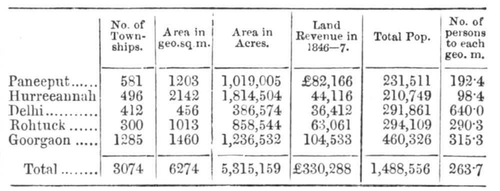
The Province’s Five Districts and Their Population
Delhi is now one of the six administrative divisions of the North-western provinces, and comprehends but a small portion of the northwest of the ancient province. It is divided into five districts, the names of which, with their area and popula tion, &c., are as follows : Paneeput, Hurreeaunah, Delhi, Rolltuck, and Goorgaon.
Bibliography
Blackie, Walker Graham. The Imperial Gazetteer: A General Dictionary of Geography, Physical, Political, Statistical and Descriptive. 4 vols. London: Blackie & Son, 1856. Internet Archive. Inline version of a copy in the University of California Library. Web. 20 December 2018.
Last modified 20 December 2018