
Then hail, ye patriots, who can prize renown
On peaceful plains, where sylvan honours crown!
Let morning air invigorate your powers,
And plans of increase mark your passing hours.
Waste long-neglected acres be your care,
And barren fields with fruitful fields compare,
The depth and kind of surface-soil explore,
How mark’d with fatness, or how ting’d with ore.* — Matthews
*Mr. SMITH, an ingenious land-surveyor, of Mitford near Bath, has studied with success this subject, and the publick, it is hoped, will ere long be benefited by a publication of his important discoveries respecting the general laws of nature in the arrangement and external signs of under-strata, inclusive of fossils and minerals. (Matthews, 65: quoted by Torrens, p. 237).
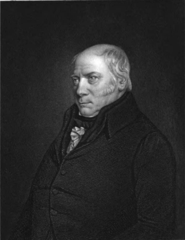
Portrait of Smith from Philips’s Memoirs of William Smith, LL.D., Author of the “Map of the Strata and Wales

he poem celebrates the progress of the eighteenth-century agrarian revolution, the note paying tribute to William Smith’s work as a land surveyor, work that led to Adam Sedgwick’s hailing him in 1831 as ‘the father of English geology’ (Gillispie, 83-85). Smith, who was born in the Oxfordshire hamlet of Churchill, the son of that most essential inhabitant of traditional English village life — the blacksmith. In many ways, blacksmiths were the precursors of the ironmasters central to the Industrial Revolution. They worked in a forge fueled by charcoal and consisting of an open hearth with a bellows attached for heating iron to render it malleable — a traditional process which the Darbys and others developed to relative perfection. Thus Smith, the father of English geology, began his life in an English rural setting leavened by his father’s one-man village industry.
That rural setting existed in an England experiencing two revolutions in both of which Smith played a part: the Agricultural and the Industrial Revolution. Agrarian revolutionaries were changing English agriculture and remodelling the English countryside. ‘Turnip Townsend’, otherwise Baron in 1661, and Viscount in 1682, initiated a practice that benefited his pocket and increased productivity on his land when he introduced turnip farming on a large scale. Jethro Tull, another agricultural innovator, invented a rotating-cylinder seed drill. When he failed to complete his degree at Oxford and was forced by illness to abandon a potential career in the law, Tull toured France for his health, learning much from French agriculturalists. On his return to England, he Townsend, Tull, and others, along with the adoption of the four-crop rotation system (wheat, turnips, barley and clover) dramatically increased agricultural output.
At the same time that agriculture became more productive, the landscape itself changed as workmen laid out new roads, dug canals, and landscaped country estates. Smith, who began his career as assistant to one of the foremost surveyors of the day, Edward Webb, played a role in these changes, most notably, when he assisted Webb in landscaping Warren Hastings’ country estate at Daylesford (Winchester, 59).
Smith’s year of birth saw several milestones in the Industrial Revolution: Richard Arkwright created the first water-powered cotton-spinning frame, and Josiah Wedgewood opening ‘Eritrea’, his pottery making factory. Another development has particular importance to Smith’s career: Colliery owners and ironmasters doubled their production every twenty years, so Smith’s work in identifying mineral-rich strata benefited both commercial and industrial entrepreneurs.
Smith had noticed how particular strata required certain identifiable conditions to develop and therefore which could be identified by the surveyors as coal-bearing. To systematize and then verify his findings, he observed, he drew, he talked to miners and discovered what they knew about the depth of coal seams and how to excavate them safely. In this he anticipated Charles Kingsley’s traveller in Glaucus. Or the Wonders of The Shore (1855) who must ‘like a knight of old, be first of all gentle and courteous, ready and able to ingratiate himself with the poor, the ignorant, and the savage…. because he knows how much invaluable local information can be only obtained from fishermen, miners, hunters, and tillers of the soil’ (197: my emphasis).
Smith’s Map of Geological Strata in England and Wales
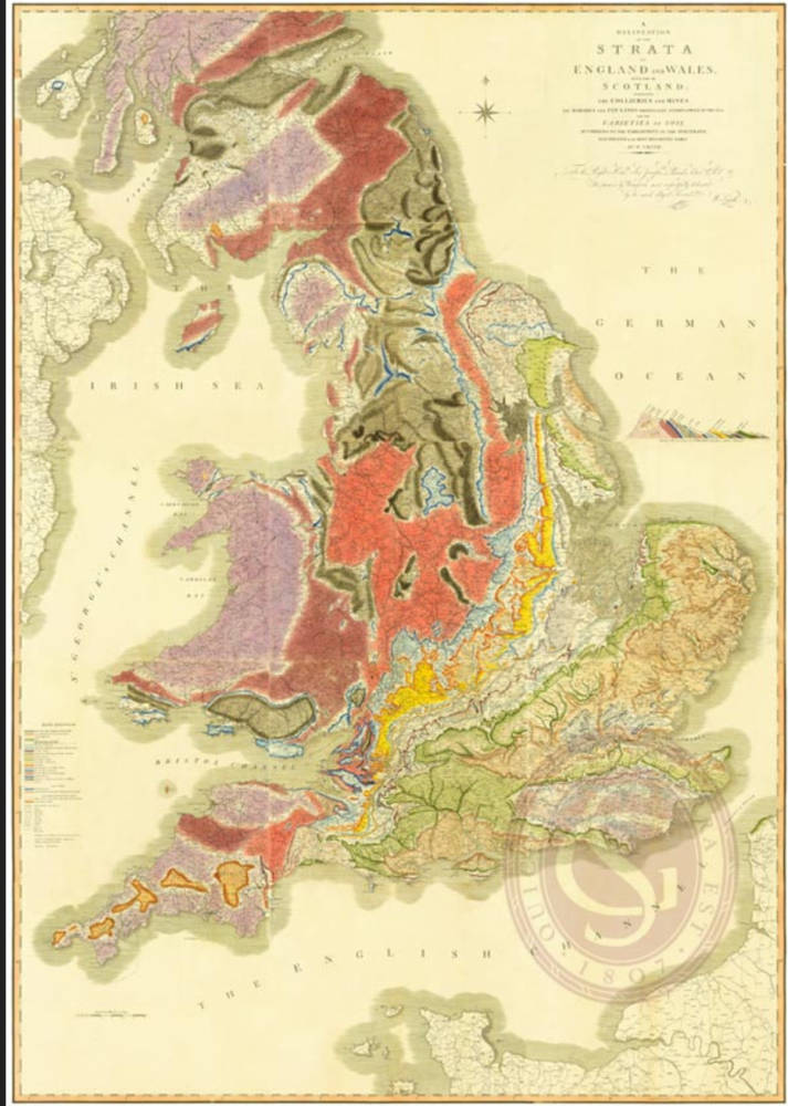
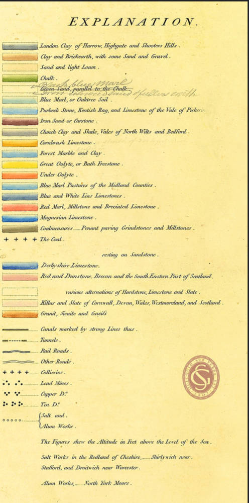
The color-coded map of geological strata and its key from Smith’s Memoir. Images from the Royal Geological Society’s Flickr account. [Click on images to enlarge them.]
As John Philips, Smith’s nephew, follower, and memoirist explains, the existence of geological strata had long been known but never really accurately described or really understood. Smith's decades of careful observations revealed both that strata rose and fell as they moved across England and Wales and also that certain strata appeared associated with mineral deposits and sources of water that had great importance in agriculture, engineering, and manufacturing. As Smith explained in the text accompanying his great map, “by a knowledge of the alluvial deposits in low marshy grounds around the coast, which I have had frequent opportunities of investigating, and by more correct information concerning the shoals and sandbanks adjacent, great benefits may accrue both to the landed and commercial interests of the country in the draining of such low lands, and in the improvement of sandy and bar harbours” (4). In addition, his geological information had great practical importance for agriculturalists: “By a classification of soils, according to the substrata, good practical farmers may choose such as are best suited to their accustomed mode of management, and they may thus be tempted to transfer useful and well-established practices in husbandry to many parts of the same stratum, which are still highly susceptible of improvement; and beneficial results will be recorded with more regularity for the advantage of others, desirous of trying experiments upon the same strata” (4). Similarly the same principles and information assist arborists by making known the best locations “for plantations of timber: miners and colliers, in searching for metals and coal; builders for freestone, limestone, and brick earth; the inhabitants of dry countries, for water; the farmer, for fossil manures; will all be directed to proper situations, in search of the various articles they require; and will be prevented from expensive trials, where there can be no prospect of success” (4-5). Finally,
Tracing the courts of springs beneath the surface, will show the best methods of draining and improving land; and the collecting of water from those natural subterraneous reservoirs, the caverns of hills and joints of rocks, for the supply of canals.
Much of the art of constructing those public works, their value and utility, and the products of collieries and mines, depends upon this science, as also the perfection and extent of potteries, glass, salt, alum, vitriol, and saltpetre works; the procurement of fullers earth, founders and glass-makers sand, of materials for chemists and colourmen, and the various substances used in grinding and policing metals and marble: in fact, there are few arts or employments which may not derive some useful hint or improvement from a better knowledge of the products of our soil and substrata. [5]
Smith’s meticulous field-work led to the creation of his famous map of geological strata. While surveying the Shropshire Canal tunnels, he began to note which strata contained fossils and the levels at which they were to be found. When he concluded that fossil-bearing rocks had uniform qualities that always appeared at the same depths (McIvor, p. 136), he placed the newly developing science of geology on a systematic basis, something that Sedgwick recognised when his 1831 address to the Geological Society declared that Smith had observed that ‘particular species of fossils’ occurred in ‘particular groups of strata, and in no others’. According to the authoritative Sedgwick, President of the Society, identifying strata by their fossil content was ‘the master principle of our science’ (Gillispie, 83-85). Appropriately, Sedwick made these observations on the Society’s honoured Smith with the highly prestigious Wollaston Medal.
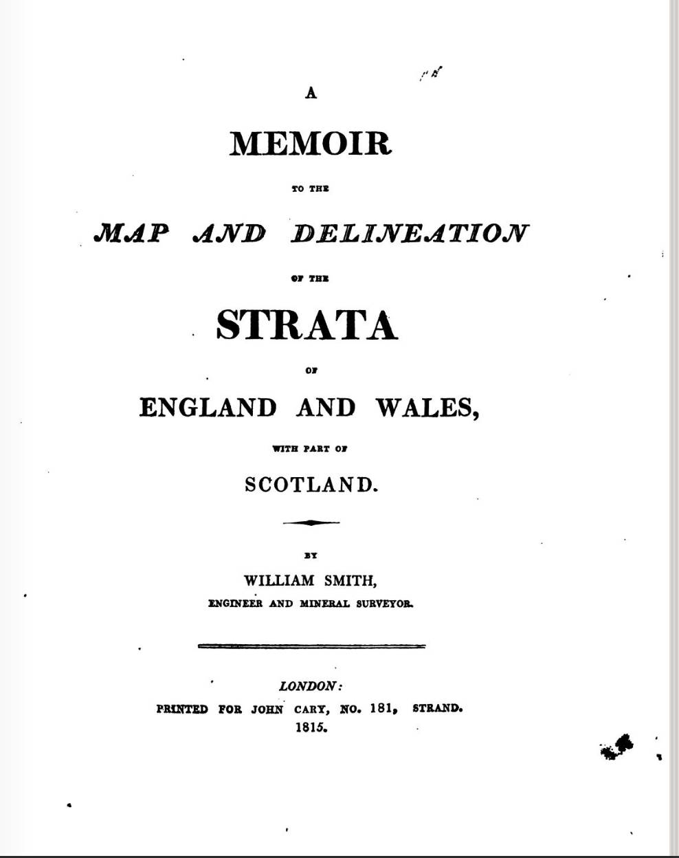
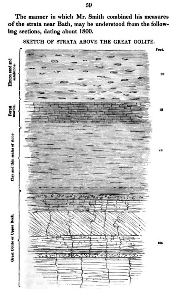
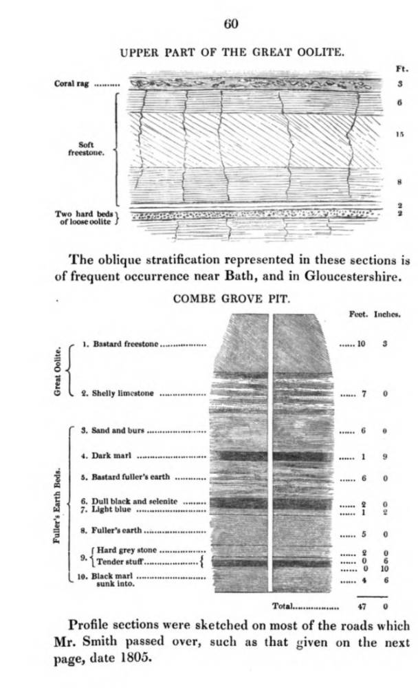
Left: The title-page of Smith’s pioneering work. Right three: Diagrams of geological strata reproduced in Memoirs of William Smith, LL.D., Author of the “Map of the Strata and Wales” by his Nephew and Pupil John Philips. F.R.S., F.G.S.. (London: John Murray, 1844). [Click on images to enlarge them.]
The Society thus acknowledged the significance of the map that Smith had unveiled in 1815, which displayed ‘his important discoveries respecting the general laws of nature in the arrangement and external signs of under-strata’. Smith grandly titled this culmination of his strenuous fieldwork ‘A Delineation of The Strata of England and Wales with part of Scotland, exhibiting the Collieries and the Mines: the Marshes and the Fen Lands originally Overflowed by the Sea; and the Varieties of Soil in the Sub Strata; illustrated by the Most Descriptive Names’.
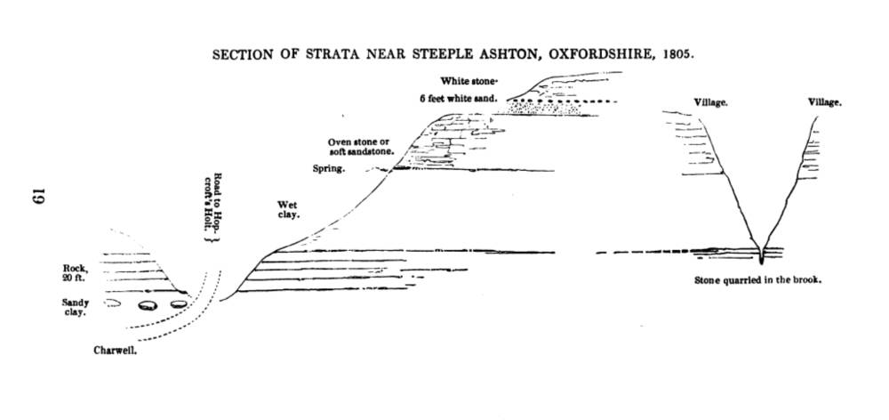
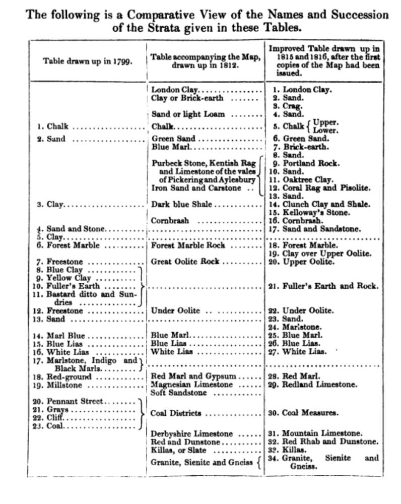
Left: A diagram of geological strata in the land near Ashton, Oxfordshire. Right: A table from Philips’s book showing the increasing specificity of Smith’s identification of geological strata in 1799, 1812 , and 1815-16. [Click on images to enlarge them.]
This sumptuously coloured map proved of the utmost importance in the British Industrial Revolution, which relied so heavily upon the coal and coke that fueled its engines and furnaces. Smith’s map guided Victorian surveyors to the much sought-after coal deposits, for like the fictional map which leads Quatermain’s party to the riches of the mythical King Solomon’s Mines in H. Rider Haggard’s novel, Smith’s spectacularly presented map led men to their fortunes in iron, tin, platinum, silver, and, above all, in oil, diamonds, and coal. It helped Victorians like Kingsley partially to realise their dream of controlling the whole of the natural world.
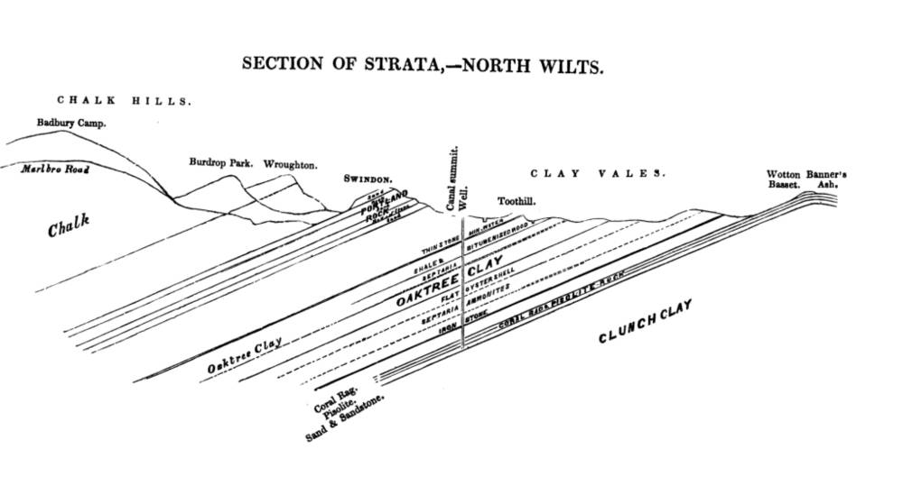
Smith’s diagram of geological strata in North Wiltshire.
Related material
- Smith’s Explanation of His Map of Geological Strata in England and Wales
- A County-by-County Geological Description of England’s Landscapes.html
- Soil and Surface Elements in the English Landscape
- The History of the Idea of Geological Strata before William Smith’s Formulation and Map
Bibliography
Gillispie, Charles. Genesis and Geology: A study in the relations of scientific thought, natural theology and social opinion in Great Britain 1790-1830. Cambridge: Harvard University Press, 1969.
Kingsley, Charles. Glaucus. Or the Wonders of The Shore. 2 vols. London. J. W. Parker & Son, 1859.
McIvor, Liz. Canals: The Making of a Nation. London: Penguin Books, 2015.
Philips, John. Memoirs of William Smith, LL.D., Author of the Map of the Strata and Wales. London: John Murray, 1844.
Smith, William. A Memoir to the Map and Delineation of Strata of England and Wales. London: John Cary, 1815.
Torrens, Hugh. "Geological Communication in the Bath area in the last half of the eighteenth century." In Jordanova, L.J. and R.S. Porter, eds. Images of the Earth. Buckinghamshire, England: British Society for the History of Science, 1981.
Winchester, Simon. The Map That Changed The World. London: The Viking Press, 2001.
Created 9 September 2018; last modified 8 September 2023